ZALA AERO GROUP performed VLS works at the licence area of OOO NOVATEK Yurkharovneftegaz

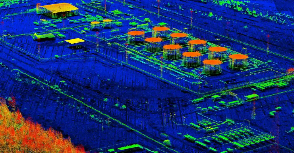
ZALA AERO GROUP performed aerial laser scanning of the licence area of OOO NOVATEK Yurkharovneftegaz.
The main tasks at the field stage were to perform geodetic works on plan-altitude substantiation of the Evo-Yakhinskoye field site and flights with an airborne laser scanner (ALS).
Preliminary results of the VLS work significantly exceeded the requirements of the technical specification. The obtained density of laser reflection points (up to 15 points per 1 m2.), made it possible to obtain relief and digital terrain model with high reliability for subsequent performance of complex design and survey, surveying and cadastral works.
The final results of the field work are currently undergoing desktop processing and will be submitted to the customer in accordance with the contract requirements.
ZALA AERO GROUP has been applying airborne laser scanning technology since 2018 in the interests of fuel and energy companies and regional executive authorities.
The results of VLS provide customers with geospatial information at all stages of the life cycle of scanning objects. Examples of objects for airborne laser scanning include mineral deposits, capital construction projects, power line surveys, etc. The results of VLS provide customers with geospatial information at all stages of the life cycle of scanning objects.
VLS technology allows to obtain accurate data on the true terrain relief in areas with dense vegetation, as well as to increase the economic efficiency of engineering and geodetic works.